Description
Mountain Ridge and Thermal Site. This site is NOT managed by the Arctic Air Walkers, and this Site Guide is provided to assist pilots in making good decisions about flying at this site.
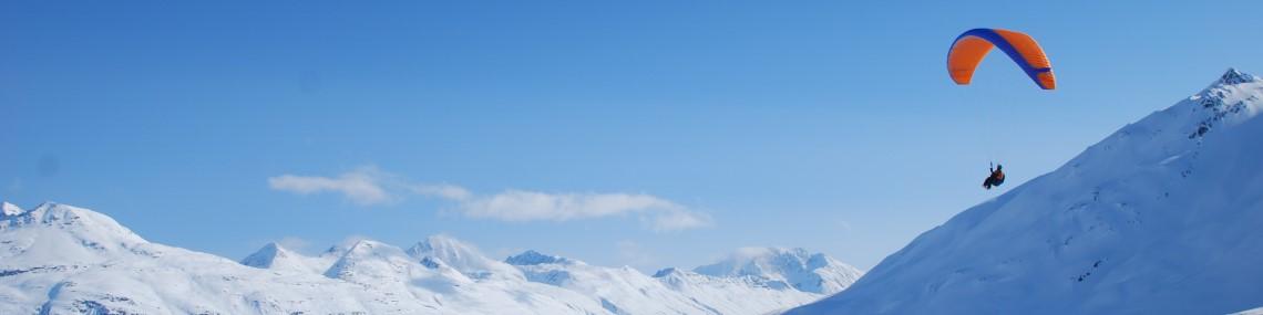
- Marmot is the somewhat obvious peak situated in the confluence of two valleys and offers several launch options. This is primarily a thermal site though the thermal lift is often assisted by a strong valley flow that’s divided into two separate valley flows on face of Marmot. The bench launch is accessed from the large "Fishhook" parking lot two miles after the sharp switchback in the road. The Marmot bench launch is about half way up the peak and provides an attractive alternative to the agonizingly steep trail to the top. There's no trail to the bench launch but once you climb a little past the cliff face on the way to the peak, take a right turn through the low brush and head toward the face of Marmot where you'll find a nice fairly flat area to layout and launch. Launches are primarily from the south to south west facing slope which faces into the valley flow.
- Access to launch is via a 1 mile partially maintained trail within Chugach State Park from the Fishhook Parking Lot at Hatcher Pass. The upper portion of the trail to the peak is steep and difficult. Trail maintenance is not allowed.
- Pilots are requested to NOT land in the Parking Lot, and instead to land in the tundra above the parking lot, or elsewhere in the tundra.
Landing Zones
Marmot LZ
61.767376, -149.265454
Mountain Ridge and Thermal Site. This site is NOT managed by the Arctic Air Walkers, and this Site Guide is provided to assist pilots in making good decisions about flying at this site.
The State Parks has asked that we not land in the Parking Lot. Instead land in the tundra above the parking lot, or on the Tundra elsewhere.
Weather Considerations
Pilots need to keep a careful watch on weather conditions, both on launch and in the air.
Ideal winds are from the South from 5 to 10 mph. Winds can be about 15 degrees to either side of that direction, or you can move to a different area to launch that faces more into the wind.
Mini-Wings are likely to be able to handle 8 to 15 mph winds, but should still be generally from the south, as described above.
Generally winds come from the South, up the Little Susitna Valley and straight into Marmot Peak.
Winds from other directions can cause turbulence from the ridges and gullys. Pilots shall use their judgement.
Requirements
Pilots are expected to evaluate the launch, the possible landing areas, the weather, and other conditions. Flights are at the Pilot's own risk.
P3 is the recommended pilot level. This site is not managed by the Arctic Air Walkers and there are no specific requirements to fly here aside from strong launching skills and good judgment. Pilots should have P3 skills, but because it is a remote site, with greater consequences for messing up, pilots should follow the USHPA recommended operating limitations for P2 pilots, which are:
- Maximum base wind of 12 mph.
- Maximum peak gusts to 15 mph.
- Maximum gust rate of 5 mph in 5 seconds
- Should not fly in thermal lift where peak climb rates exceed 200 fpm.
- Launch from slopes steeper than 4:1 with the wind within 25 degrees of being straight up the slope.
This site is not managed by the Arctic Air Walkers.
- This is remote backcountry flying site which requires suitable pilot skills and good decision making.
- The Bench launch is suitable for P2 pilots
- The Upper launch is suitable for P3 pilots due to the steeper slope, and more likely tricky wind conditions as the peak is more narrow and rocky.
Hazards
Other hikers/spectators/berry pickers may occasionally visit this site and the potential for a conflict exists. Pilots are cautioned to ensure an appropriate distance is maintained between launch and landing activities and the public. Pilots are expected communicate to the public as needed to maintain clearances.
This is a natural mountain site and there are many natural hazards that are common to many natural mountain sites in Alaska that could be a hazard for pilots.
There may be no cell phone reception in many backcountry areas. Pilots are expected to be prepared for self-rescue and by carrying Spot, InReach or other non-cell based communication equipment.
- Massive overdevelopment is one of the biggest hazards at Hatchers Pass. It’s very common for towering cumulonimbus clouds to blast into the sky past 30,000 feet. These clouds will suck you up, chew on you for hours, and spit your frozen corpse out somewhere in the remote and inaccessible Talkeetna Mountains. Be aware that this development can occur quickly above you and it’s not always obvious that it’s happening until it’s too late. Blue sky over the Matanuska-Susitna Valley doesn’t mean that you’re safe. In fact it often means that you’re not. Scared? Good.
- There are a lot of converging, diverging, and mixing valley flows in the Hatcher Pass area. Stay alert.
- Winds can shift quickly. Be prepared.
- Pilots often try to fly along the east and west flanks of Marmot. If you choose to do this be aware of mechanical turbulence along the spines leading up mountain and be aware that the strong valley flows will probably make this a one way trip.
- Landing at the Mint Valley Trailhead often results in backwards landings because of the strong valley flow. It’s doable but not the best option.
- The State Parks has asked that we not land in the Parking Lot. Instead land in the tundra above the parking lot, or on the Tundra elsewhere.
WARNING: The descriptions of typical flying conditions listed in this Site Guide reflect the experience of the authors of the guide. The conditions that you encounter at the site may differ, sometimes substantially, from those described. These descriptions may not be relevant to the possible experience of any other pilot, particularly one who is relatively inexperienced or new to the Site.