Description
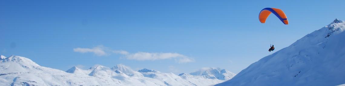
Fireweed Mountain is located near McCarthy, a remote town in Alaska within the Wrangell-St. Elias National Park and Preserve at the end of a 60 mile dirt road. Flying in the area was largely pioneered by Wil Brown and many opportunities remain for some exceptional first flights over stunning terrain.
Access to launch is via a steep, 3,000ft, 2-hour hike that starts at the McCarthy Road Information Station. Hike north about a 1/4 mile down the well established trail that starts behind the outhouse to a well traveled community trail that branches to the left. Follow that trail another 2 miles up to launch. It's steep and usually hot so bring plenty of water. The most common launch for southerly/thermic days is in a small depression just past the last vegetated high point on the trail. Trail Map
There's no designated landing zone but there are many gravel bars and combination roads/airstrips to land within McCarthy. Per capita, McCarthy probably has more aistrips than any other place so be hyper aware of air traffic as you descend and avoid descending within the approach path of any of these airstrips. The most common and safest place to land is the airstrip that also serves as a road to the west of the Kennicott River.
Landing Zones
McCarthy Road/Runway
61.432277, -142.937795
While there are many places to land in the McCarthy area, this is probably the safest location. It seems to align reasonably well with the valley flows, is not frequently used by aircraft or vehicles, and is within quick walking distance from the popular camping area on the east side of the foot bridge. walk to the the north east end of the runway to pack-up your wing so that other aircraft and vehicles can use the runway.
Weather Considerations
- This site is south facing so is probably best on days with light winds that don't have an north component.
- The winds can be strong in the valley mid-day so use caution and be conservative in your fly/no-fly decision making
Requirements
It may or may not be legal to launch from this peak which is in the Wrangell-St. Elias National Park. That said, many people have flow this site, the rangers are aware of people flying from here, and it hasn't been an issue. Keep a low profile though.This site is not managed by AAW nor is it insured by USHPA.
-
Pilots are expected to evaluate the launch, the possible landing areas, the weather, and other conditions. Flights are at the Pilot's own risk.
P3 is the recommended pilot level, and it may not be suitable for P2 pilots. This site is not managed by the Arctic Air Walkers and pilots are expected to have strong launching skills and good judgment. Pilots should have P3 skills, but because it is a remote site, with greater consequences for messing up, pilots should follow the USHPA recommended operating limitations for P2 pilots, which are:
- Maximum base wind of 12 mph.
- Maximum peak gusts to 15 mph.
- Maximum gust rate of 5 mph in 5 seconds
- Should not fly in thermal lift where peak climb rates exceed 200 fpm.
- Launch from slopes steeper than 4:1 with the wind within 25 degrees of being straight up the slope.
Hazards
- This is a remote mountain site in a very remote part of Alaska - be sure that you have appropriate skills and experience needed before flying here.
- This is serious Alaska backcountry flying. Medical and rescue facilities may not be available.
- There are many locations not too far from McCarthy where you could land but find it impossible to walk back to town. You should have strong backcountry hiking and navigation skills if you plan to fly cross country. Consider pre-arranging for a heli retrieve as a contigency.