Description
|
Pilot Recommendations
P3 skills recommended
In person site intro recommended, especially for pilots flying XC |
Weather Conditions Wind Direction: 100° - 330° Min: 0mph / Ideal:5-8mph / Max:10mph / Gust:5mph
|
Hazards This is a backcountry site that is flown infrequently. Pilots should only fly here if they are confident in judging conditions appropriate to their skill level Ideal launch conditions can vary greatly during time of year and time of day. Pilots are urged to watch conditions for a while before committing to launch Hazards can include, but are not limited to, water crossings, heinous bushwhacking, animal encounters, weather exposure, extreme terrain and difficult, complex navigation |
|
Restrictions Do not land within 50' of other recreators |
||
Mountain Ridge and Thermal Site. This site is NOT managed by the Arctic Air Walkers, and this Site Guide is provided to assist pilots in making good decisions about flying at this site.
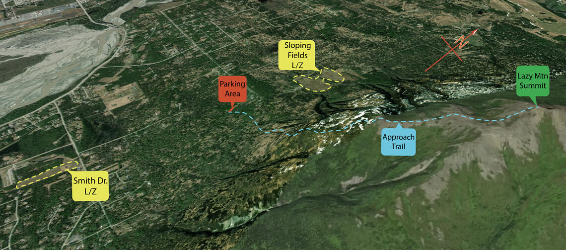
Lazy Mountain is located in Palmer at the confluence of the Matanuska and Knik River Valleys. This site has been flown on and off throughout the years and has recently become more popular. The hike is 1 to 2 hours with an elevation gain of approximately 2,000ft. Some members of the Arctic Airwalkers have made an agreement with a land owner at the bottom of the trail head to land on his land. It is a big open field with no wind indicators. See picture attached. Important to place windsock up before hiking up. It is highly recommended that pilots new to the site contact one of the experienced Lazy Mountain flyers on Slack before flying this site.
Launch

Landing Zones
Lazy Mt. LZ at Smith Dr.
61.596380, -149.020275
One of the preferred landing zone options for flying from Lazy Mountain.
Some members of the Arctic Airwalkers have made an agreement with a land owner at the bottom of the trail head to land on his land. It is a big open field with no wind indicators. See picture attached. Important to place windsock up before hiking up. It is highly recommended that pilots new to the site contact one of the experienced Lazy Mountain flyers on Slack before flying this site.
Sloping Grass Fields
61.618363, -149.014349
This is the primary LZ for Lazy Mountain. You'll notice an overgrown air strip at the bottom of the fields. Follow this airstrip south until another field appears on your right. Walk downhill away from the airstrip toward the bottom of the field where you will find an overgrown road cut. Follow this road cut to the main road which will take you to the Lazy Mountain parking lot.
Weather Considerations
Pilots need to keep a careful watch on weather conditions, both on launch and in the air.
Ideal winds are:
Wind Direction: 100° - 330°
Min: 0mph / Ideal:5-8mph / Max:10mph / Gust:5mph
Requirements
Pilots are expected to evaluate the launch, the possible landing areas, the weather, and other conditions. Flights are at the Pilot's own risk.
This is a backcountry site with a general recommendation that pilots be P3 level or above.
It is flown infrequently, all hazards inherent to flying a backcountry site in Alaska may be present.
These hazards can include, but are not limited to, water hazards, heinous bushwhacking, animal encounters, weather exposure, extreme terrain and difficult, complex navigation.
Pilots must be comfortable evaluating weather and landing conditions from the air.
This site is located in a complex mountain environment, and strong knowledge of local weather patterns is recommended.
Hazards
Other hikers/spectators/berry pickers may occasionally visit this site and the potential for a conflict exists. Pilots are cautioned to ensure an appropriate distance is maintained between launch and landing activities and the public. Pilots are expected communicate to the public as needed to maintain clearances.
This is a natural mountain site and there are many natural hazards that are common to many natural mountain sites in Alaska that could be a hazard for pilots.
There may be no cell phone reception in many backcountry areas. Pilots are expected to be prepared for self-rescue and by carrying Spot, InReach or other non-cell based communication equipment.
WARNING: The descriptions of typical flying conditions listed in this Site Guide reflect the experience of the authors of the guide. The conditions that you encounter at the site may differ, sometimes substantially, from those described. These descriptions may not be relevant to the possible experience of any other pilot, particularly one who is relatively inexperienced or new to the Site.


