Description
|
Pilot Recommendations P2/M1 In person site intro recommended
|
Weather Conditions Wind Direction: 120°-240° Min: 0mph / Ideal: 8-10mph / Max: 12mph / Gust: 3mph Glide Ratio to L//Z: 4.5 |
Hazards Beware of days with strong SE in surrounding areas! This can quickly push through and cause severe turbulence and sink There are converging, diverging, and mixing valley flows. Stay alert. This is an unmaintained mountain site. All launch locations require special attention to detail, there are limited setup sites with rock hazards to both your lines and footing. |
|
Restrictions Do not land within 50' of other recreators Do not land while farm equipment is operating |
||
This site is not managed or maintained by the Arctic Air Walkers, and this Site Guide is provided to assist pilots in making good decisions about flying at this site. Always seek out pilots with site experience to get a site orientation.
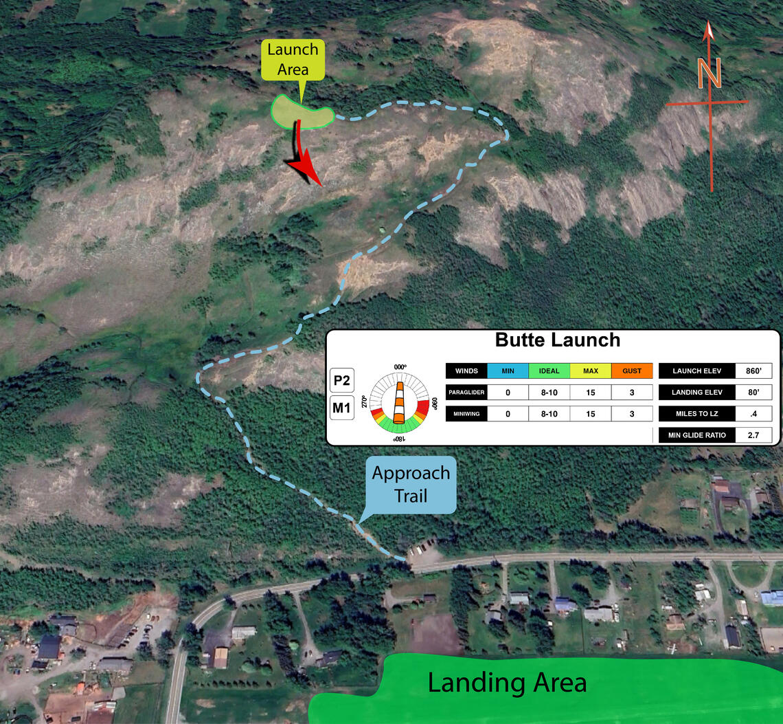
Year round, the Butte is a often flown site in the Anchorage area due to easy access and a quick hike. It offers launch options towards the south and can be flown on days when SE winds make flying at other Anchorage sites impossible.
The Butte is an 850 foot hill surrounded by flat land, in the middle of the Matanuska Valley, about 10 miles south of Palmer. It is accessed from the Sandvik Family Trailhead off the Old Glenn Highway via Bodenburg Loop Rd. There is good parking with a 35 minute hike up a well worn trail to the launch site.
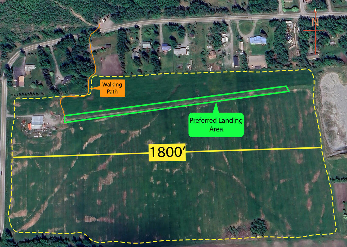
Do not land while farm equipment is working near the landing strip. During the summer when crops are on the field ensure all landing, walking, and packing activities take place on the unmaintained airstrip on the north end of the field. No landing in the crops. Winter landing can take place anywhere in the landing field.
The Butte makes a good mini/speed wing site as it has significant vertical relief with little to no glide requirements as long as the LZs at the base of the mountain are used.
No permanent wind indicators are maintained in the LZ. It is the responsibility of the pilot to place temporary wind indicators if needed.
Launch

The Butte is an ideal location to launch a paraglider from. With a flat and open area that faces south there are many possible setup locations. The setup area is generally grassy, with the occasional rock. The biggest hazard on launch is the steep slope that develops as you move south. Gliders should be kitted up reversed, or further back set up areas should be utilized to ensure the glider is fully inflated for forward launches before running down the steep slope.
The trail up to launch is quite steep and sandy, but easy to navigate. To get to launch, you take a hard left off the main trail just below the final band of trees below the summit. Follow this around to the west until you reach a nice grassy south facing area.
The main detractor of the area is the finicky and variable weather conditions. This site work well for ridge soaring and, with thermal influence, soaring several hundred feet over launch is common.
If launching a mini/speed wing, be very confidenet of your launch. With the steep rolloff, care must be taken to ensure a fully inflated wing before launching.
The launch is natural, and unmaintained. Maintenance or "grooming" of any kind if forbidden by the Mat Su Borough, and could jeopardize our future access.
Landing Zones
The Butte LZ
61.540198, -149.050936

The primary LZ is a large field just south of the butte with an unmaintained airstrip on the north edge. During the winter, early spring, and late fall all areas of the field can be utilized as a landing.
After crops are planted and before harvest the owner has requested that all landings, packing of wings, and walking to the road take place on the airstrip.
The airstrip faces E/W and is generally easy to land on. Paragliders have special permission to access the LZ by walking through the yard across the street from the trailhead.
No one should drive onto the LZ, as we don't want to damage the crops or cause ruts, or cause other potential problems. Pilots and others are expected to show all courtesy to the site and the land owners, with no loud discussions, and to use the Port-A-Potty at the adjacent Trailhead.
When exiting the field, walk to the west end of the runway, then walk north to the fence and follow that to the trailhead.
Houses, barns, and equipment are nearby and should be watched out for during landing. If farm equipment is present in the field participants should land far away or wait for them to finish.
No permanent wind indicators are maintained in the LZ. It is the responsibility of the pilot to place temporary wind indicators if needed.
Weather Considerations
Pilots need to keep a careful watch on weather conditions, both on launch and in the air.
- Works best when the winds aloft are light. S/SW/W winds up to 10mph.
- High wind launches are possible but generally indicate strong thermals and should only be launched by a skilled pilot.
- DO NOT launch if the winds are from North/East/West; expect strong gust and rotor from over the back.
- Winds can shift quickly at launch and in the LZ's due to convergence, divergence, and mixing valley flows.
- Strong SE from the Knik glacier can pick up suddenly. If dust is present in the Knik valley pilots have about five minutes to land before winds will pick up over 20 MPH in the LZ.
Requirements
Pilots are expected to evaluate the launch, the possible landing areas, the weather, and other conditions. Flights are at the Pilot's own risk.
P2 is the recommended pilot level, but conditions outside of P2 limits may exist. Beginner Speed wing pilots should be accompanied by an experience speed wing pilot until they can gain the experience and skills to safely fly the site.
South Launch Recommended Use Parameters:
Glide Ratio to LZ, 2.7: Min Wind 0 MPH. Ideal wind, 8-10 MPH, directions from 120 to 240 degrees. Max wind 12 MPH with 3 MPH gusts
Hazards
Other hikers/spectators/berry pickers may occasionally visit this site and the potential for a conflict exists. Pilots are cautioned to ensure an appropriate distance is maintained between launch and landing activities and the public. Pilots are expected to communicate to the public as needed to maintain clearances.
This is a natural mountain site and there are many natural hazards that are common to many natural mountain sites in Alaska that could be a hazard for pilots.
- Hike all the way to the top, winds from the surrounding valleys can create false wind indicators.
- DO NOT launch if the winds are from North/East/West.
- DO NOT land in the LZ if equipment is present.
- There are converging, diverging, and mixing valley flows. Stay alert.
- While a relatively low elevation site, be aware that general aviation occurs everywhere in Alaska.
WARNING: The descriptions of typical flying conditions listed in this Site Guide reflect the experience of the authors of the guide. The conditions that you encounter at the site may differ, sometimes substantially, from those described. These descriptions may not be relevant to the possible experience of any other pilot, particularly one who is relatively inexperienced or new to the Site.


