Description
|
Pilot Recommendations
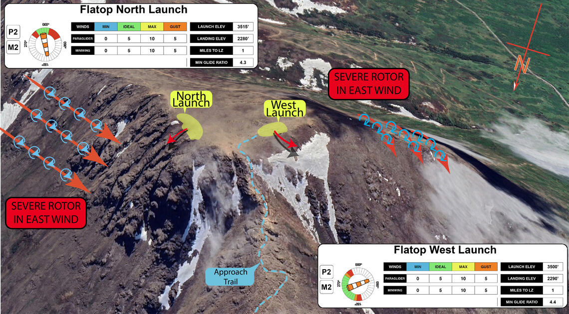
P2/M2 - Cliff Launch skill recommended for North Launch
P3 skills recommended for XC flights
In person site intro recommended, especially for pilots flying XC |
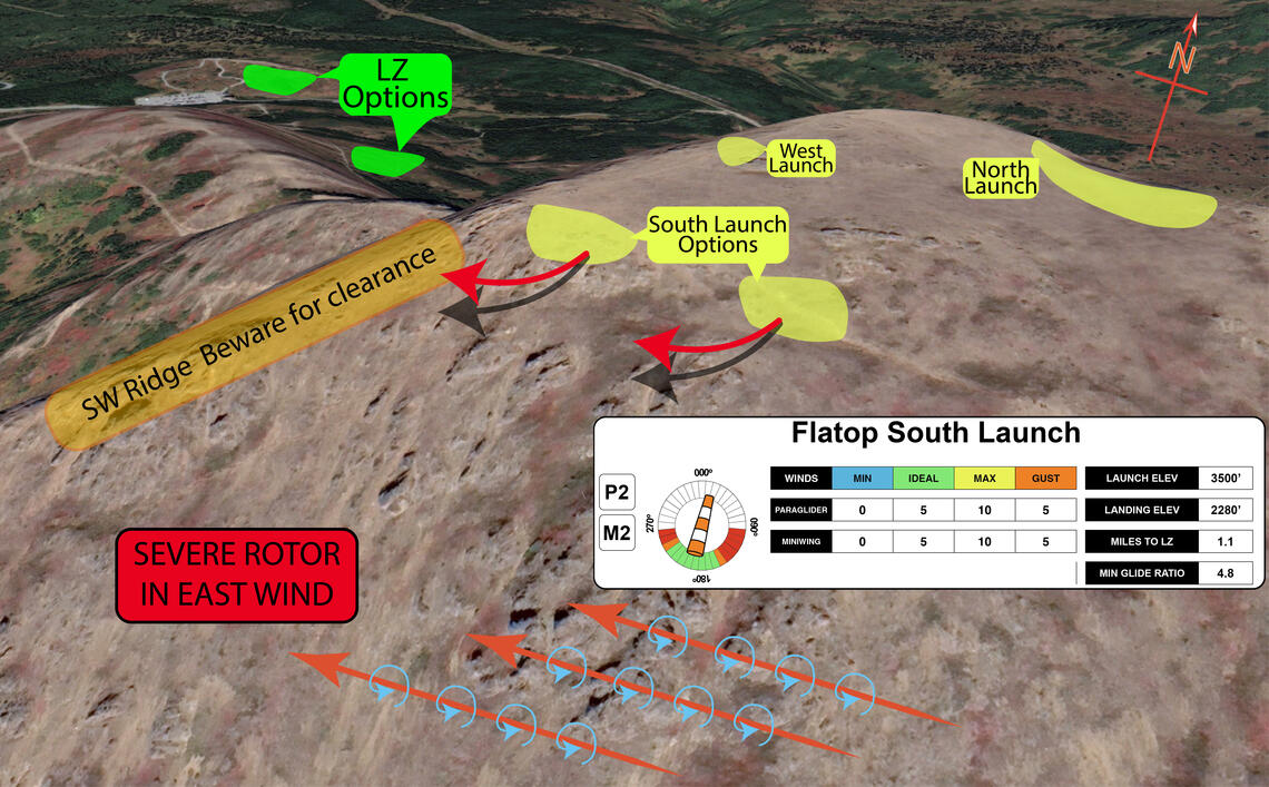
Weather Conditions North Launch: Wind Direction: 10°-330° Min: 0mph / Ideal: 5mph / Max: 10mph / Gust: 5mph Glide Ratio to L/Z: 4.3 West Launch: Wind Direction: 200°-300° Min: 0mph / Ideal: 5mph / Max: 10mph / Gust: 5mph Glide Ratio to L/Z: 4.4 South Launch: Wind Direction: 160°-230° Min: 0mph / Ideal: 5mph / Max: 10mph / Gust: 5mph Glide Ratio to L/Z: 4.8 |
Hazards Beware of days with strong SE in surrounding areas! This can quickly push through and cause severe turbulence and sink There are converging, diverging, and mixing valley flows. Stay alert. This is an unmaintained mountain site. All launch locations require special attention to detail, there are limited setup sites with rock hazards to both your lines and footing. The north launch is a cliff launch, and requires strong skills to use This is a very popular hiking area. There will be spectators for your launch. Please make sure that they are a safe distance away. The trail is quite steep at the top, and can be very icy in the winter. Traction spikes are reccommended. |
|
Restrictions Do not land within 50' of other recreatorsDo not land at either the upper or lower parking lots - The lower lot can be used when it is closed in the winter |
||
This site is not managed or maintained by the Arctic Air Walkers, and this Site Guide is provided to assist pilots in making good decisions about flying at this site. Always seek out pilots with site experience to get a site orientation.
Year round, Flattop is perhaps the most frequently flown site in the Anchorage area due to easy access and its close proximity . It offers launch options in all directions except easterly. All launches from Flattop require exceptional launch skills.
While Flattop has not historically been a good XC departure site due to the challenging terrain nearby, more and more people have had success flying the front range heading north in recent years.
Do not land in the parking areas.
Maintain an appropriate distance between launch and landing activities and the public.
Launch
The summit of Flattop is an ideal location to launch a paraglider from. With a flat top and open areas that face north, west and south there are many possible setup locations. The main detractor of the area is the sharp, rocky ground and the finicky and variable weather conditions. Being at the junction of the Turnigan Arm and 3 major valley systems, conditions can change very quickly. It is not uncommon to have the wind switch 180° in the time it takes you to setup. Because of this, it is imperative to check the weather forecasts, local weather station and, most importantly, always be ready to hike back down. Even with these restrictions, Flattop is one of of the most commonly flown sites, and for good reason. The views of the Arm to one side, the Chugach mountains behind you, and the Alaska range in the distance cannot be beat.
The approach to all of the launches is via on of the most popular hiking trails in Anchorage. Park at the Glen Alps trail head parking lot, and follow the obvious trail that heads towards the west face of the peak. The trail quite well maintained for an Alaska trail,but does have some loose footing and light scrambling, in particular in the final segment before the top. If you are hiking the trail in the winter or spring, some sort of traction is recommended, as the trail can be quite icy.
There are 3 main launch areas at Flattop, the North Launch, West Launch and South Launch. Each of these have their own intricacies, but all share similar ideal winds and common hazards. All launches are natural, unmaintained mountain locations. Maintainence or "grooming" of any kind if forbidden by the Park Service and could jeopardize our future access.
With the popularity of this site with hikers, you will most likely not be alone on launch. It is very common for people to as to record your flight. Please make sure that all spectators are aware of the space requirements for launch, and are outside of them.
North and West Launch

The North launch is a true cliff launch and the cliff launch special skill sign off is highly recommended. However, it does have the best setup location, a large flat area facing the direction of launch. The lift is mostly commonly ridge lift, but can occasionally be be thermic. It is highly recommended to walk to the lip before setting up at a particular location. Some area have fingers/ridges of rock that appear farther down the face. If the winds are light, be confident in your forward launch skills as the opportunity to abort is very limited.
The West launch is the most commonly flown launch on Flattop. It faces towards the LZ, has a relatively gentle roll-off and, mot importantly, has the most "rock free" launch. There is a great setup spot about 200' south of where the trail meets the top near a small rock outcropping. There is just enough room to layout two wings side by side. There is plenty of space to do a forward launch, but the "runway" is still quite short, and there are plenty of rocks around that can trip you. It is highly recommended to thoroughly inspect the area before launching to identify any hazards.
Be very aware of any east component to the wind, as it can cause severe rotor along the face. Winds from the east can also quickly ramo up in strength, going from nil to gusting 40 in a matter of minutes.
South Launch

The South launch has several areas to setup in that are, unfortunately, all quite rocky. This is by far the most snag prone launch location, and is the farthest from the standard LZ options. There is also a ridge that extends down SW that you need to fly around. Generally clearance is not an issue, but be aware that getting too low on this side can result in needing to land out to the south of the approach trail.
The first setup option is just off the west face, and provides the most elevation and best clearance around the ridge. It is very rocky, and extreme care must be taken during setup and launch. Snagging/cutting a line is a very real possibility. The terrain rolls off quite quickly and steeply, so strong launch skills are a must for this location.
Walking a little farther to the east, you will reach a shallow depression that is quite a bit cleaner, and provides a great launch option. This is a great spot to launch in light south winds, as there is a gentle gradient and plenty of room to get the wing inflated. From this launch, you will need to be quite mindful of your altitude in relation to the SW ridge. It is recommended to head directly to cross, unless you immediately find lift.
Beware of possible rotor from south winds as you wrap around the ridge. If the south flow is particularly strong, it is a good idea to wait before wrapping around towards the LZ areas.
Landing Zones
Flattop Overlook
61.104752, -149.682711

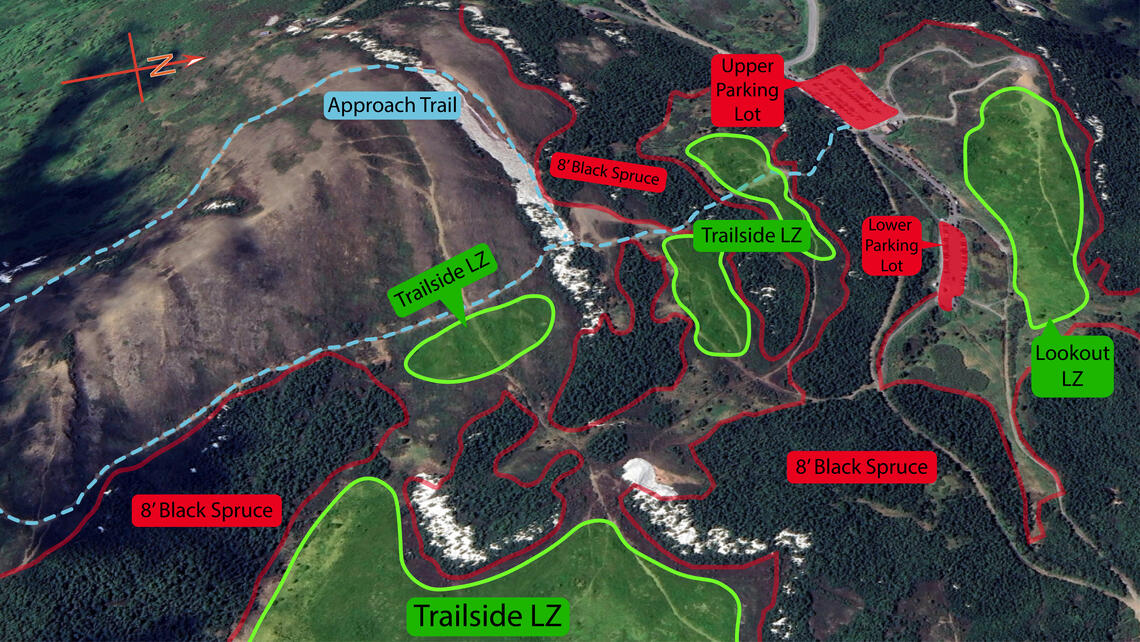
The Overlook LZ is the obvious east-west ridge-top clearing to the north of the Glenn Alps parking lot, and also encopmasses the tundra field to the south and east of the ridge. This is a fantastic LZ that can be used in all wind directions. It is prominent enough that a landing can be setup from any side, with the most common being along the east end. It is imperative that you do not overfly the LZ, as there are no other options besides tree landings. There is plenty of space to land short of the apex of the ridge. This is a very common hiking area, and it is recommended to arrive with enough altitude to inspect the area and setup accordingly. Do not land within 50' of other users, there is plenty of area to allow for this.
It is a good idea to walk the LZ prior to landing here for the first time. There are several wood fences to avoid that can be difficult to spot from the air. If you are approcahing from the south with a strong north wind, be aware of the potential for rotor on final approach. If this is the case, landing in the flats to the east is a better option.
Flattop - Trailside
,
The Flattop Trailside LZs consist of a series of clearings along the approach trail that you will hike past on your way to launch. The first clearing in just to the south of the parking area, right as you get above the trees. The hiking trail runs through the middle of it. It is oriented west east, with a slight slope to the east. this LZ option is surrounded by low alders and black spruce, making for a tangly but soft option if you overrun your landing. The next clearing is a little farther along, and is to the north of the trail. It is similar in size to the first, with a similar orientation and slope.
Following the trail along the north side of Blueberry Knoll, you will reach the next LZ option just below the beginning of the hill. This is oriented more north/south, but has plenty of space to the east as well. This is one of the larger LZ options, and is a great choice for pilots who might be making a second lap. If choosing to land here, be aware of any wind from the south or west, as you would be landing in the lee. A bit farther along the trail and more to the east is another large clearing. This is the final Trailside LZ option. This site does require a small walk back up to the trail, but is a great choice for pilots on speed/mini wings.
Weather Considerations
Pilots need to keep a careful watch on weather conditions, both on launch and in the air.
- Works best when the winds aloft are light. Southwest/West winds up to 10mph
- DO NOT launch if the winds are from North East/East/South East; expect strong gust and rotor from Peak 2 or from the east side cliffs. If the winds are strong in Turnagain Arm the wind direction will generally be from the East, you will be hiking down.
- Parks and Rec recently added a Glenn Alps Parking Lot Web Cam.
- Some Hillside area weather stations are in sheltered areas, and DO NOT provide accurate wind data.
- Winds can shift quickly at launch and in the LZ's due to convergence, divergence, and mixing valley flows.
Requirements
Pilots are expected to evaluate the launch, the possible landing areas, the weather, and other conditions. Flights are at the Pilot's own risk.
P2 is the recommended pilot level, and pilots thinking to fly XC should have P3 skills. Beginner Speed wing pilots should be accompanied by an experience speed wing pilot until they can gain the experience and skills to safely fly the site.
Hazards
Other hikers/spectators/berry pickers are very common at this site. Pilots are cautioned to ensure an appropriate distance is maintained between launch and landing activities and the public. Pilots are expected communicate to the public as needed to maintain clearances.
This is a natural mountain site and there are many natural hazards that are common to many natural mountain sites in Alaska that could be a hazard for pilots.
- Hike all the way to the top, winds from the surrounding peaks can create false wind indicators.
- DO NOT launch if the winds are from North East/East/South East.
- DO NOT land in the main Glen Alps Parking Lot, even if there are few cars. Winter landing at the lower parking lot is acceptable, but NOT any time that the lower lot is open for parking.
- There are converging, diverging, and mixing valley flows. Stay alert.
- Winds can shift quickly on top it is not uncommon to have winds shift 180 degrees while you are preparing to setup.
- Pilots often try to fly around from the South launch to land at Glen Alps. If you choose to do this be aware of mechanical turbulence as you fly around the West face, this a one way trip and you may need to land on Blueberry Hill.
- Be cautious when cloud deck is close to launch level.
WARNING: The descriptions of typical flying conditions listed in this Site Guide reflect the experience of the authors of the guide. The conditions that you encounter at the site may differ, sometimes substantially, from those described. These descriptions may not be relevant to the possible experience of any other pilot, particularly one who is relatively inexperienced or new to the Site.


